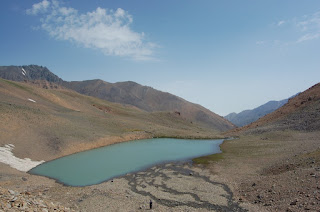
Whatever the spelling, this summit is one of the most beautiful in Iran. Alam which means pennon is shaped like one. Kooh means mountain in Farsi. Alam Kooh or Alam Kuh at 4850 m ASL is the second highest summit in Iran. The distance of the summit point to the Caspian Sea which sits at 27 m below sea level is a mere 25 KM. This area of the Iran therefore has one of the biggest altitude differences in the world.
The Alam Massif covers an area in the Alborz Mountains which is a paradise for trekking, climbing, ski-mountaineering and paragliding.
Alam Kooh is traditionally and most commonly trekked via Hesarchal plateau.
To get to Hesarchal you need to get to Kelardasht first. Kelardasht is a large (approximately 1500sq km) plateau that houses many villages. The distance to the beginning of the plateau from the Caspian Sea is some 50 KM and from Tehran it is 170 KM. A good tarmac road links the Caspian littoral and the Capital to the area.
This area of outstanding natural beauty has become a playground for the wealthy Iranians and sadly lost a lot of its old charm: small settlements inhabited by farmers and their families living in wattle and daub houses have given way to extravagant and soul-less holiday homes. Many of the villages are to date inhabited by Kurdish speaking people forcibly removed from their land in western Iran under the reign of Reza Shah Pahlavi in the 1920's.The village of Hasan Kif is the centre of Kelardasht.
The old Mountaineering Federation office and dormitories are located in the village of Rudbarak. There is a large communal kitchen and a car-park. As a non-Iranian hiker you are required to pay an entry fee and register before continuing to the mountains.
From Roodbarak there are generally two tracks which mountaineers would be interested in. Both require 4WDs which may be hire locally. One goes towards Vandarbon where there is a large newly built refuge with many private rooms, communal kitchen, toilets and shower, the other road takes you deep into the mountains and a place called Tange Galoo which is at 3700m.
Tange Galoo is as far as vehicles go and from here you would hike to Hesarchal which lies at 4000m. The mules depart from this point also. The muleteers are notorious for their bad temper so be ware! In high season they are also in short supply so you are advised to book them well in advance.
Adjacent to the Vandarbon refuge, close to the sparsely populated village at 2250 m ASL, there are several paths. The most commonly used trail is the one that would take you to Sarchal refuge ( 3850 m) some 6 hours away. Sarchal has some bunk beds and running water. No shops or other amenities.
Sarchal is the starting point for many of the famous 4000ers of the region including Takht-e-Soleyman summit 4650m, Alam Chal (4000m) , Siyah Sangha route, and the mighty Alam Kooh wall one of the most emblematic walls in Iran with a height of 800m ( 550m if you deduct the glacier).
Mules go as far as Alam Chal.


